
IIRS (Indian Institute of Remote Sensing, Dehradun)-ISRO Outreach Programmes have been initiated by IIRS-ISRO as an extension of scope of utilizing EDUSAT/INSAT 4CR satellite for distance learning to use the internet to avail access to a large number of institutions/universities /individuals with little cost to the user. Today these programmes are linking more professional and user departments and ministries in the country to develop their skills in geospatial technologies and its applications.
V.V.P. Engineering College, Rajkot has been an Active Nodal Center for IIRS -ISRO Outreach Programmes since June 2020 to avail the benefits of IIRS Outreach Programmes for students and Staff members.
V.V.P. Engineering College, Rajkot has also received the prestigious Best IIRS Nodal Center Award 2022 all over India on 28-3-2023.
The details of the IIRS Outreach programmes conducted so far (V.V.P. Engineering College, Rajkot as being the Focal Center) as given as below:
| Sr. No. | Name of IIRS Outreach Program | Duration |
|---|---|---|
| 1 | Space Technology Applications | 10-01-2025 |
| 2 | Geodata Processing using Python and Machine Learning | 17-2-2025 to 28-2-2025 |
| 3 | Martian Surface, analogues and atmosphere | 12-03-2025 |
| 4 | Remote Sensing of Soils: mapping, classification and evaluation of Agricultural Land Use Planning | 3-3-2025 to 7-3-2025 |
| 5 | Space Technology for Disaster Risk Reduction | 24-3-2025 to 28-3-2025 |
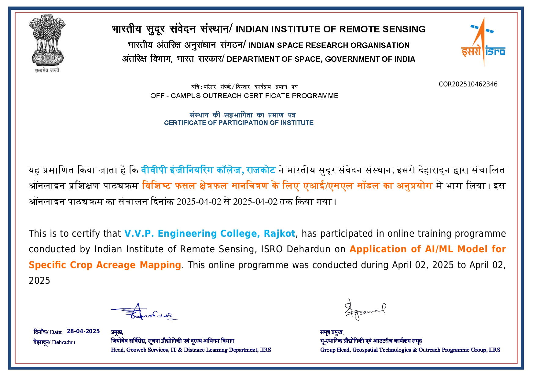
| 6 | Application of AI/ML model for specific crop Acreage | 02-04-2025 |
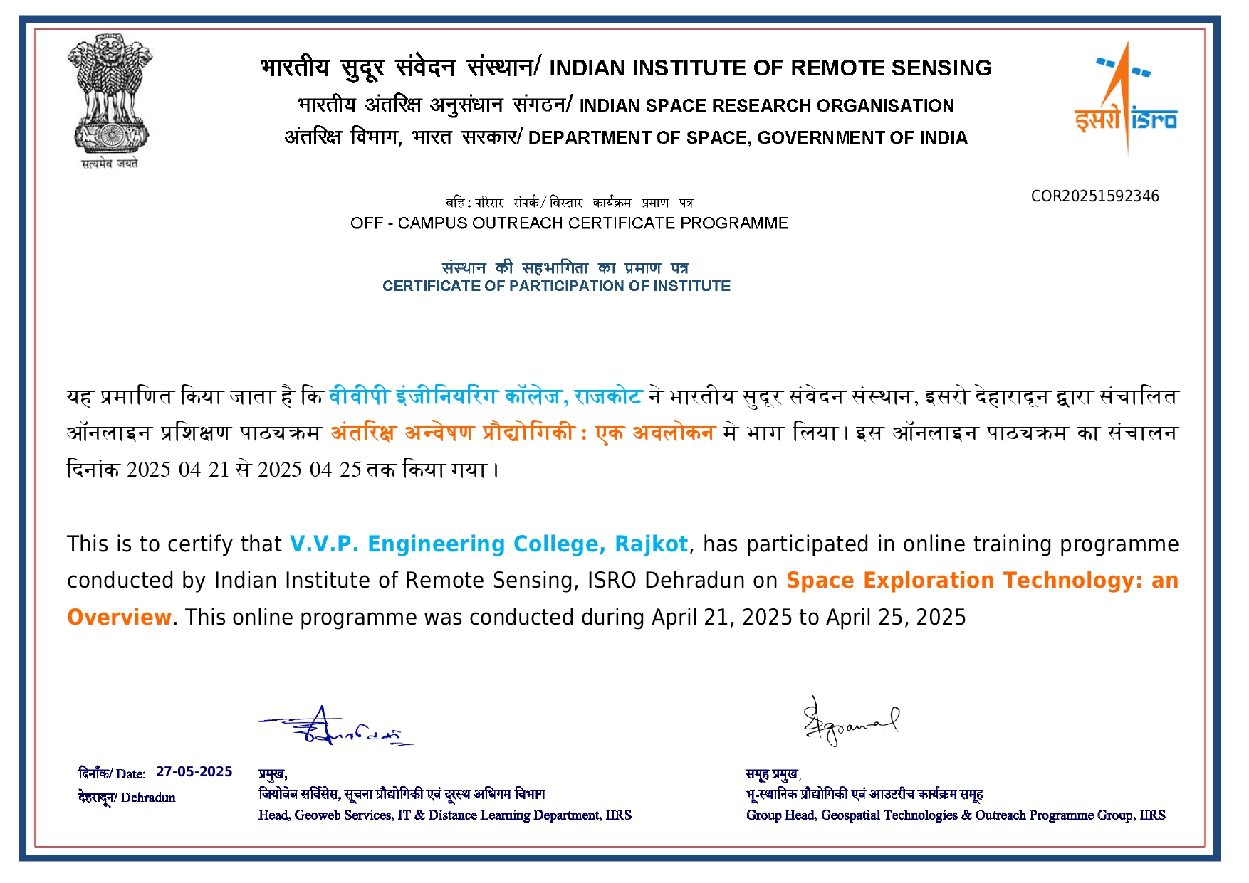
| 7 | Space Technology: an Overview | 21-4-2025 to 25-4-2025 |
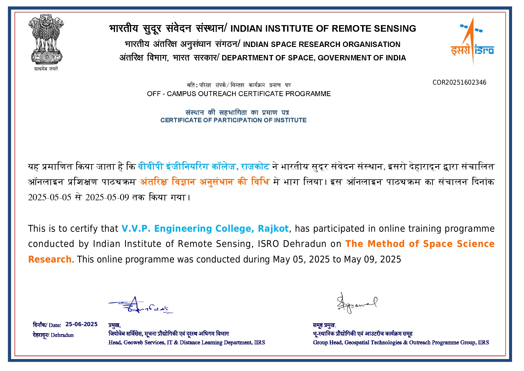
| 8 | The Method of Space Science Research | 5-5-2025 to 9-5-2025 |
| 9 | Recent Trends in Ecological Modelling & Simulation | 19-5-2025 to 23-5-2025 |
| 10 | Geospatial Technology for modelling of Urban Environment | 26-5-2025 to 30-5-2025 |
| 11 | Remote Sensing Data Analytics for Crop Production Forecasting | 16-6-2025 to 20-6-2025 |
| Sr. No. | Name of IIRS Outreach Program | Duration |
|---|---|---|
| 1 | Geodata processing using Python | 15-1-24 to 19-1-24 (1 week) |
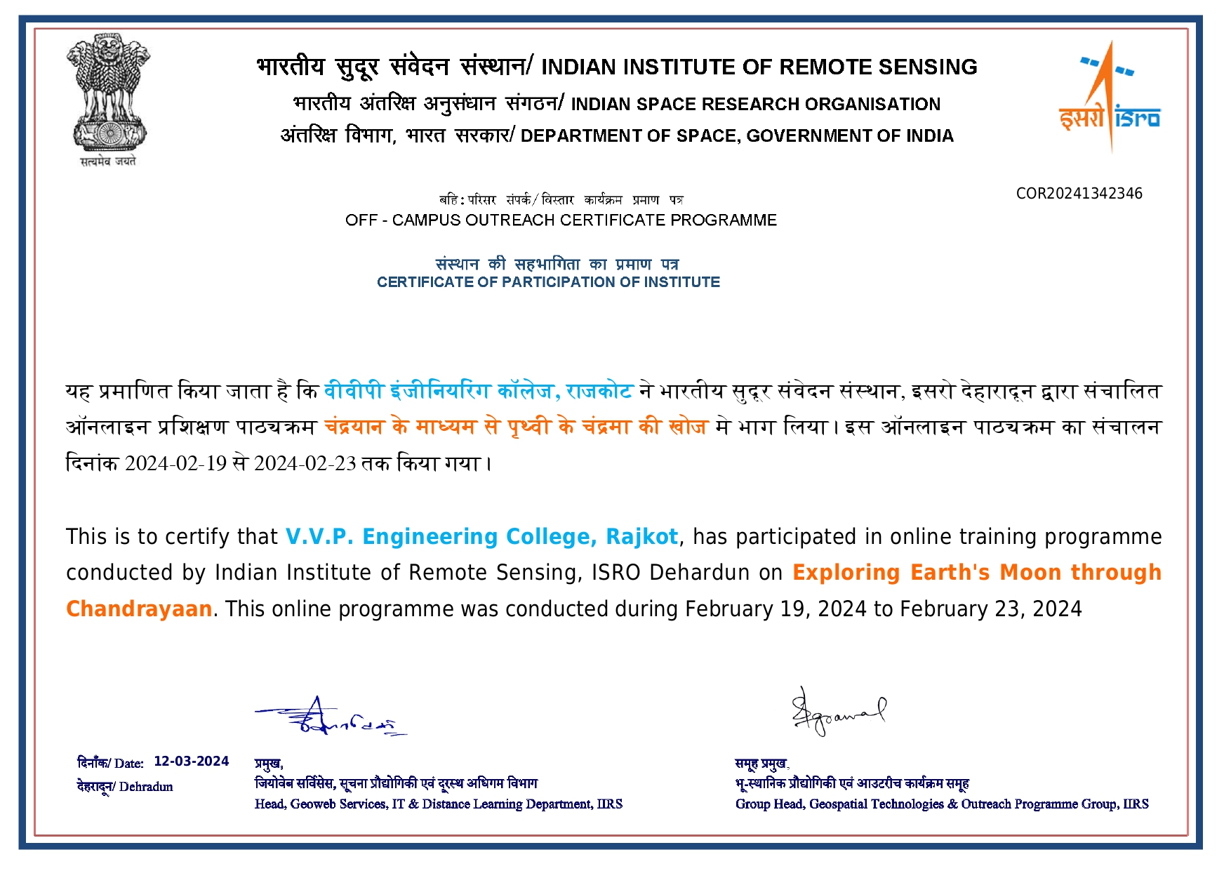
| 2 | Exploring Earth's Mission Moon through Chandrayaan | 17-2-24 to 24-2-2024 (1 week) |
| 3 | Geospatial Analysis using Google Earth Engine | 19-2-24 to 24-2-2024 |
| 4 | Advances in Remote Sensing Techniques for Geological Applications | 11-3-24 to 15-3-24 |
| 5 | Aditya L1: India's first space based obervatory | 18-3-24 to 23-3-24 |
| 6 | Soil Health: Measurement and Monitoring | 28-03-2024 |
| 7 | Forest Carbon and Water cycle monitoring | 13-5-24 to 18-5-2024 |
| 8 | Applications of Geospatial Technologies in Paleochannel studies (in Hindi) | 20-5-24 to 24-5-24 |
| 9 | Geospatial Technology for modelling of Urban Environment | 27-5-2024 to 31-5-2024 |
| 10 | Geospatial Technology for Digital Agriculture | 24-6-2024 to 28-6-2024 |
| 11 | Utilities of sun -induced chlorophyll Floroscence in vegetation studies | 18-07-2024 |
| 12 | Potential of NISAR for disaster mitigation and management | 24-07-2024 |
| 13 | LiDAR data processing and applications | 5-8-2024 to 16-8-2024 |
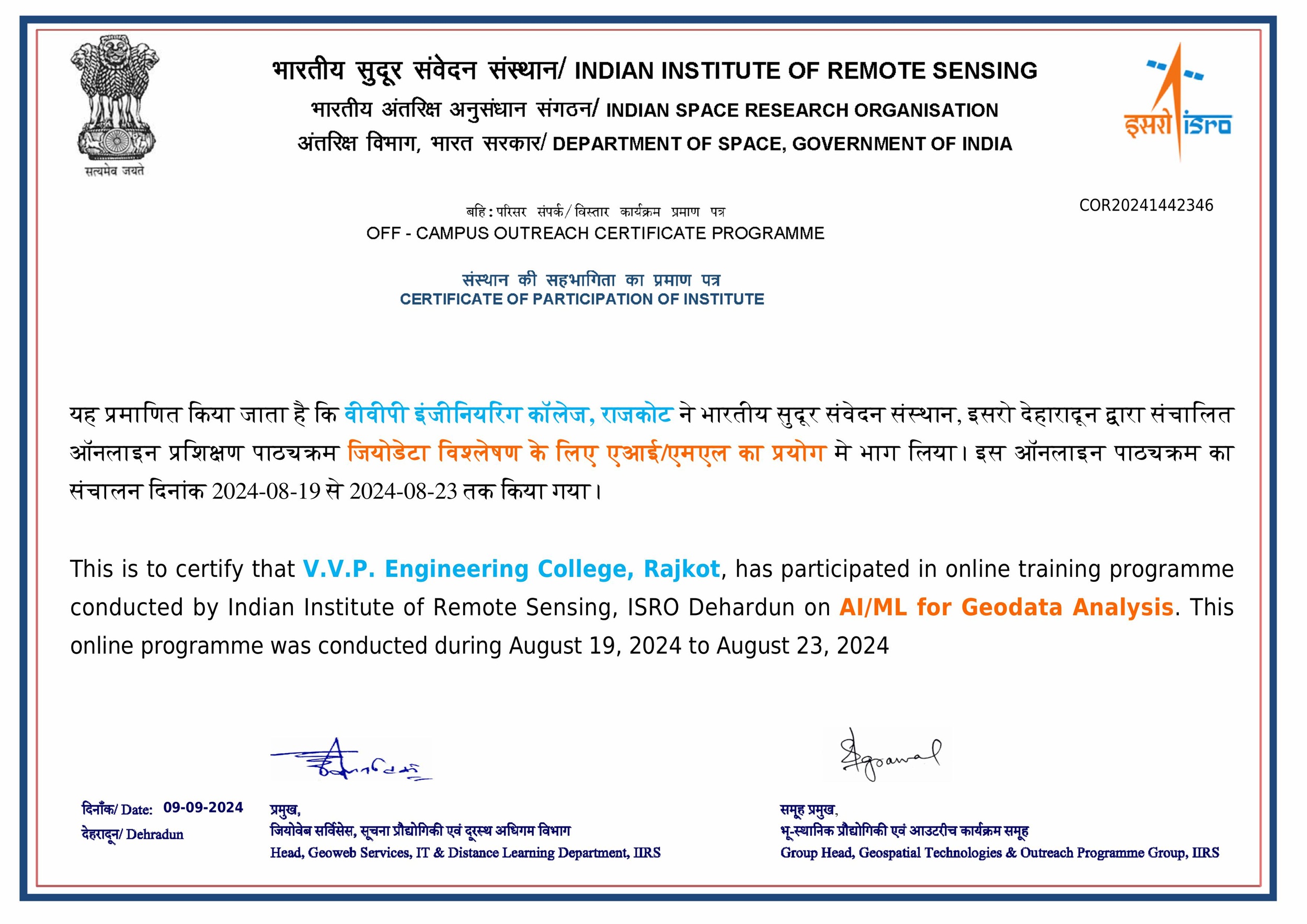
| 14 | AI/ML for Geodata Analysis | 19-8-2024 to 23-8-2024 |
| 15 | Basics of Remote Sensing, Geographical Information System and Global Navigation Satellite System | 27-8-24 to 22-11-24 |
| 16 | Remote Sensing and Digital Image Analysis | 27-8-2024 to 20-9-2024 |
| 17 | Understanding Cryospheric Hazards | 06-09-2024 |
| 18 | Overview of Space Technology | 9-9-24 to 20-2024 |
| 19 | Overview of Global Navigation Satellite System | 23-9-24 to 4-10-24 |
| 20 | Overview of Geographical Information System | 14-10-2024 to 1-11-2024 |
| 21 | Space inputs for village-level crop assessment | 28-10-2024 |
| 22 | Overview of Geocomputation and Geo web services | 4-11-24 to 8-11-24 |
| 23 | RS & GIS Applications in Natural Resource Management | 11-11-2024 to 22-11-2024 |
| 24 | Deep Learning in Ecological studies | 27-11-2024 |
| 25 | Geo-data sharing and cyber security | 9-12-2024 to 20-12-2024 |
| 26 | Raman Spectroscopy | 24-12-2024 (1 Day) |
| Sr. No. | Name of IIRS Outreach Program | Duration |
|---|---|---|
| 1 | Karyshala on Space Technology and its Applications | 10-01-2023 (1 day) |
| 2 | Geodata Processing using Python | 20-2-2023 to 25-2-2023 (1 week) |
| 3 | Geospatial Modeling driven urban hazard and risk analysis | 13-2-23 to 17-2-23 (1 week) |
| 4 | RS and GIS Applications in Atmospheric and Oceanic Hazards | 27-2-23 to 3-3-23 (1 week) |
| 5 | Advances in Remote Sensing Techniques for Geological Applications | 13-3-23 to 24-3-23 (2 weeks) |
| 6 | SAR Data Processing & its application with special emphasis on RISAT 1-A/EOS-4 | 10-4 to 14-4-23 (1 week) |
| 7 | Overview of Free and Open Source Software for Geospatial Technology | 24-4-23 to 28-4-23 (1 week) |
| 8 | Geomatics in Urban studies | 24-5-2023 (1 day) |
| 9 | Applications of Machine Learning in urban studies | 5-6-23 to 9-6-23 (1 week) |
| 10 | Geospatial Technology for Climate Smart Agriculture | 10-7-23 to 14-7-23 (1 week) |
| 11 | Geospatial Technology for Archeological studies | 7-8-23 to 11-8-23 (1 week) |
| 12 | Satellite Meteoroly Applications in weather and climate studies | 7-8-23 to 11-8-23 (1 week) |
| 13 | Integration of ground based in situ observations/measurements with EO data for enhanced Geological Applications: Advantages and Challenges | 24-8-2023 (1 day) |
| 14 | Basics of Remote Sensing, Geographical Information System and Global Navigation System | 28-8-23 to 17-11-23 (12 weeks) |
| 15 | Remote Sensing and Digital Image Analysis | 22-8-23 to 22-9-23 (5 weeks) |
| 16 | Overview of Space Technology | 14-9-23 to 28-9-23 (2 weeks) |
| 17 | Global Navigation Satellite System | 25-9-23 to 6-10-23 (2 weeks) |
| 18 | Monitoring Forest Disturbances using Geospatial Technology | 4-10-23 (1 day) |
| 19 | Geographical Information System | 9-10-23 to 27-10-23 (3 weeks) |
| 20 | Remote Sensing based data Analytics in Agriculture | 26-10-23 (1 day) |
| 21 | Basics of Geocomputation and Geo-webservices | 30-10-23 to 3-11-23 (1 week) |
| 22 | RS & GIS Applications in Natural Resource Management | 6-11-23 to 17-11-23 (2 weeks) |
| 23 | Automated Feature Extraction from High Resolution Images | 20-11-23 to 24-11-23 (1 week) |
| 24 | Geo-data sharing and Cyber Security | 28-11-23 to 11-12-23 (2 weeks) |
| 25 | Edicovariance Techniques for Ecosystem studies | 22-12-2023 (1 week) |
| 1 | Karyashala on Space Technology and Applications | 10-1-22 (1 day) |
| 2 | Overview of Geoprocessing using Python | 17-1-22 to 28-1-22 (2 weeks) |
| 3 | Global Navigation Satellite and location based services | 21-2-22 to 4-3-22 (2 weeks) |
| 4 | Hyperspectral and Microwave Remote Sensing Techniques for Geological Studies | 7-3-22 to 17-3-22 (2 weeks) |
| 5 | Advanced Geospatial Technologies for Disaster Risk Reduction | 18-4-22 to 29-4-22 (2 weeks) |
| 6 | Artificial Intelligence for Earth Observation and Geodata Handling & Processing | 2-5-22 to 13-5-22 (2 weeks) |
| 7 | Status, Challenges and opportunities for Geospatial technology applications in irrigation water management | 17-5-22 (1 day) |
| 8 | Planetary Exploration of the Moon : Findings from Remote Sensing Missions | 20-5-22 (1 day) |
| 9 | Geospatial applications for Forest Eco-system analysis from | 20-6-22 to 25-6-22 (1 week) |
| 10 | Machine learning to deep learning : A journey for remote sensing data classification | 4-7-22 to 8-7-22 (1 week) |
| 11 | Satellite Remote Sensing of Atmosphere from | 11-7-22 to 15-7-22 (1 week) |
| 12 | Remote Sensing & GIS Applications in Agriculture | 25-7-22 to 29-7-22 (1 week) |
| 13 | Water Quality studies using hyperspectral remote sensing for the Indian Coastal and Inland waters | 5-8-22 (1 day) |
| 14 | Basics of "Remote Sensing, Geographical Information system & Global Navigation Satellite System | 22-8-22 to 25-11-22 (14 weeks) |
| 15 | Remote Sensing & Digital Image Analysis | 22-8-22 to 16-9-22 (4 weeks) |
| 16 | Applications of Remote Sensing & GIS Technology (Hindi) | 14-9-22 to 18-9-22 (1 week) |
| 17 | Global Navigation Satellite System | 19-9-22 to 30-9-22 (2 weeks) |
| 18 | Overview of Geographical Information System | 3-10-22 to 28-10-22 (4 weeks) |
| 19 | Applications of Geospatial technology in Paleochannel studies : Potential and Future trends | 11-10-2022 (1 day) |
| 20 | Geo data sharing & cyber security | 17-10-22 to 21-10-22 (1 week) |
| 21 | Overview of Geocomputation and Geo web services | 31-10-22 to 4-11-22 (1 week) |
| 22 | UAV Remote Sensing | 21-11-22 (1 day) |
| 23 | RS & GIS Applications in Natural Resource Management | 11-11-22 to 23-11-22 (2 weeks) |
| 24 | Advances in monitoring and modelling of hydro meteorological hazards using geospatial technology and process based models | 5-12-22 to 9-12-22 (1 week) |


Prof. Sheron Henry Christy
Assistant Professor,
Department of Electronics & Communication,
Focal Coordinator,
V. V. P. Engineering College, Rajkot
Contact No : 9624074443
sheron.christy.ec@vvpedulink.ac.in